
The plan Republicans forced through the Legislature meets standards for compactness and contiguity, the judge ruled
BY: RUDI KELLER
Missouri Independent
The gerrymandered congressional map pushed through the General Assembly by Republicans meets constitutional requirements for districts to be compact and contiguous, a Jackson County judge ruled Thursday.
The decision from Circuit Judge Adam Caine is the third Missouri court ruling to reject a constitutional challenge to the plan intended to shift the 5th Congressional District to the Republican Party. In earlier rulings, Cole County Circuit Judge Christopher Limbaugh has upheld Gov. Mike Kehoe’s authority to convene the special session that passed the plan and the legislature’s power to enact it without a new census report.
In Thursday’s ruling, Caine did not address the question of whether lawmakers had authority to enact the map. That question, he noted, is in the hands of the Missouri Supreme Court, which heard the appeal on Tuesday.
Lawmakers approved the map in September under pressure from President Donald Trump to help maintain the slim Republican majority in the U.S. House. Along with the legal challenges to the map itself, opponents who hope to force a referendum submitted more than 300,000 signatures in December.
The referendum has become a major legal tangle of its own, with cases over which signatures should be checked and whether the map passed in September is in effect for this year’s election.
Incumbent Democratic U.S. Rep. Emanuel Cleaver, meanwhile, has filed for re-election, with five Republicans already filed for the August primary.
Caine took evidence in the case filed by the Washington, D.C.-based Campaign Legal Center , the ACLU Voting Rights Project and the ACLU of Missouri over four days in February. The evidence, he wrote, was not enough to convince him to override the legislature.
While discussing historic district maps and the plan passed in 2022 that last year’s enactment is intended to replace, Caine noted that Kansas City and Jackson County have been split into multiple districts for decades and other counties around the state have been whole and split at various times.
“The result of plaintiffs’ position in these cases would be for the court to make value judgments about which communities should be divided in redistricting plans,” Caine wrote.
In a statement Thursday afternoon, Attorney General Catherine Hanaway called the ruling “a complete victory for Missouri and for the people’s elected representatives.”
Caine’s ruling will be appealed, the three organizations said in a joint statement.
The map violates the Missouri Constitution’s requirements that districts be as compact as possible, the statement read.
“Drawn under direct pressure from the Trump administration, the map divides the Kansas City area across multiple sprawling districts in clear violation of that constitutional mandate,” the organizations said. “If allowed to stand, it would represent a significant setback for fair representation in Missouri.”
At trial, Caine consolidated two cases with common claims. In one, the lawsuit argued that the map was unconstitutional because a precinct identifier was used twice in the law enacting the districts. There are two distinct geographic areas with the same designation — VTD 811 — in the Census Bureau files used for determining the population of any particular location.
The only confusion was that there are two, Caine wrote. Each, he wrote, “has a unique GEOID, a unique alphanumeric identifier, that allows mapping software to assign each separately to the appropriate district.”
A large portion of the ruling is a discussion of particular measures of how compact the districts were.
“The 2025 plan is not an outlier and is within historical measures of compactness scores,” Caine wrote.
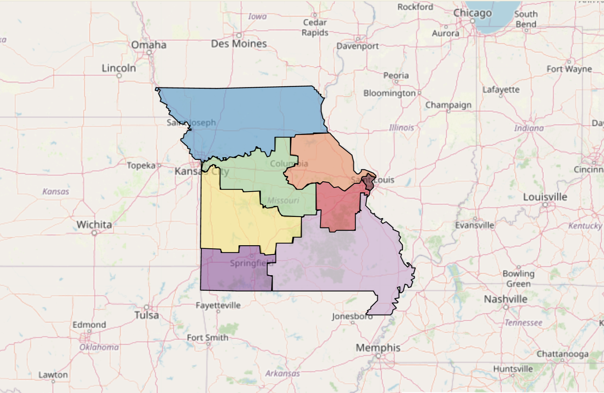
The new map splits five of Missouri’s 114 counties, with seven total portions from those five. The map approved in 2022 split nine counties, with 10 total portions. The number of municipalities in two or more districts was reduced from 30 to 13, Caine wrote.
Under the map approved by lawmakers in 2022, the 5th District is entirely contained within Jackson and Clay counties and includes most of Kansas City south and north of the Missouri River.
The map approved by lawmakers last year puts portions of Kansas City north of the river into the 6th District, and puts sections of the city into the 4th and 5th Districts and pairs those areas with places as far away as Columbia in the 5th District and Lebanon in the 4th District.
The organizations challenging the map argued that splitting Kansas City and Jackson County divided it as a community of interest and diminished its ability to influence the selection of representatives.
In his ruling, Caine wrote that Kansas City, and Jackson County, has a larger portion of the population in the 4th, 5th and 6th districts than any other community.
Each Missouri congressional district has 769,364 people counted in the 2020 census. Kansas City has 126,008 people in the 4th District, 174,515 in the 5th District and 207,567 people in the 6th District, Caine wrote. Sedalia, the largest city in the 4th District, has 21,275 people, he wrote, and Jefferson City, the largest city entirely within the 5th, has 43,228.
Jackson County has 330,299 people in the 4th District compared to 109,638 in Cass and 370,868 in the 5th District, compared to 77,278 in Cole County.
“This court,” Caine wrote, “finds it is more helpful to engage in an objective review of the 2025 plan rather than be guided by subjective factors like policy preferences and views of current representation.”